interTwin Use Case

A Digital Twin for Drought Early Warning in the Alps

Developing the components to set up a Drought Early Warning System for the Alps

Challenge

The Alps have been marked as the water tower of Europe for many decades because of their glacier-rich mountains, snowfields, and underground aquifers. Despite being protected from prolonged droughts due to its temperate climate and high elevation, in recent decades the Alpine region has faced several drought events. This situation primarily stems from shifting climate patterns that have resulted in a decline in water resources. Furthermore, climate projections indicate that rising water demand is expected in the future, resulting in greater susceptibility to drought in the region.

Traditionally, physically based hydrological models have been used to simulate the terrestrial water cycle and extreme events (flood and droughts) in the Alps. Nevertheless, these models require a substantial amount of data and require lengthy calibration procedures.

In accordance with the EU’s new policy on adapting to climate change, decision making should take place in view of uncertainty, and be based on the latest scientific knowledge. The use of cutting-edge digital technologies and climate services is integral to facilitating decision-making through digital transformation.

Solution

In the intertwin project, we aim to combine process-based hydrological models and machine learning methods for exploiting the potential of Earth Observation to improve the representation of surface processes and conditions in hydrological models. These methods are used to build a hydrological Digital Twin for the Alps supporting the implementation of a drought early warning and prediction system at river basin scale.

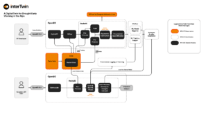
The prototype is developed and integrated into openEO as a user interface for researchers who can test the performance of a drought early warning system using a trained model and EO data. They can also contribute to further enhancing the trained model. The digital twin is also helpful for public authorities in the field of agriculture and river basin management to identify areas potentially affected by hydrological drought.

The application of the drought digital twin in this context is critical for improving risk assessment for past, present, and future climate change impacts on water availability in the and in areas which depend on Alpine water availability.

Workflow Description

We use the spatially distributed hydrologic model Wflow_sbm to estimate hydrological fluxes including snow accumulation and melt, actual evapotranspiration, soil moisture and streamflow. The first phase involves training a surrogate model, i.e., a machine learning model emulating the functioning of the process-based model Wflow_sbm. This step is necessary to support a differentiable workflow and to optimize the use of computational resources.

Once the surrogate model is trained, the parameters of the hydrological model are optimized based on historical observations and static inputs by minimising the loss function between model outputs and observations, namely soil moisture, which plays an integral role in drought prediction. As soon as the parameters are optimized, the model will be run driven by reanalyses and seasonal forecast data in order to simulate past and future hydrologic conditions and identify/predict drought events. Currently, we have developed a surrogate model for the Adige catchment, in Italy, and are extending it to other Alpine catchments.